NASCO Wild Atlantic Salmon Atlas
The NASCO Wild Atlantic Salmon Atlas
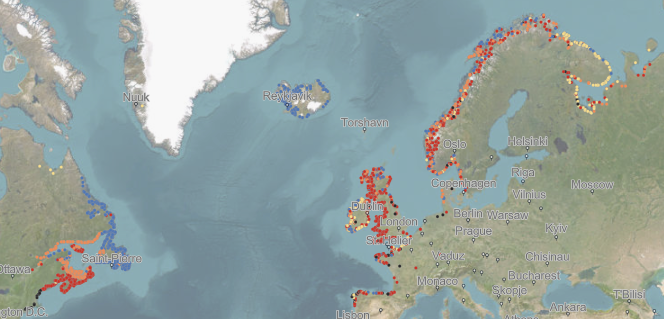
NASCO’s Wild Atlantic Salmon Atlas is a new, interactive map which gives information on wild Atlantic salmon populations in almost 2,500 rivers across the North Atlantic, from Portugal to Arctic Russia in the east and from New England to Ungava Bay in the west.
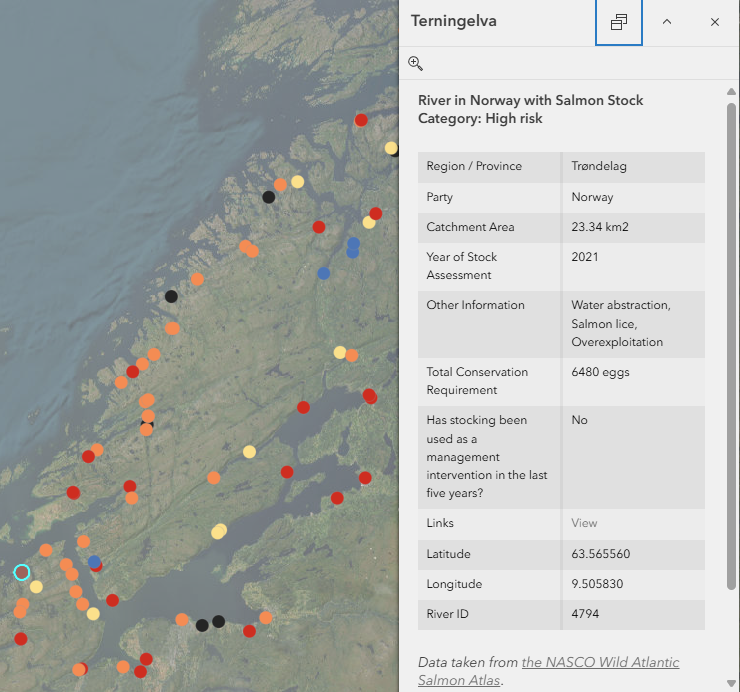
The Atlas can be searched for detailed data on individual salmon rivers. The information available includes the risk status of a river’s wild Atlantic salmon stocks and, in many cases, the factors influencing those stocks, the size of the catchment area and useful links relating to the river.
The information on the rivers has been supplied by countries that are party to NASCO’s Convention, which are referred to as NASCO’s ‘Parties and jurisdictions’, and is displayed by individual country. General information, including the percentage of rivers in each risk category and the main impact factors affecting wild Atlantic salmon at a national level, is given for each country. An overview of the status of the wild Atlantic salmon stocks across the North Atlantic as a whole is also provided.
Each of the rivers included in the Atlas has been assigned a ‘Risk Category’ by the Party / jurisdiction responsible for including the river. These risk categories are for use in the Atlas only and are not a scientific assessment. The categories have been assigned by translating domestic stock assessments into the categories agreed by NASCO in 2022 and shown in Table 1 below.
Table 1. Risk Categories used in the Atlas
| NASCO Salmon Stock Risk Category | Description |
| Low Risk | Risks to the wild salmon population are considered to be low or absent |
| Moderate Risk | Risks to the wild salmon population are considered to be moderate |
| High Risk | Risks to the wild salmon population are considered to be high |
| Lost | Atlantic salmon no longer exist in these rivers |
| Unknown | There are known or believed to be Atlantic salmon. There are not enough data to assess their status or risk |
Click here or on the image below to go to the NASCO Wild Atlantic Salmon Atlas
The majority of the information included in the Atlas was provided by NASCO’s Parties / jurisdictions in 2024. However, the data shown may have been collected in a different year. Clicking on a river point will open the information box which will include the year the stock assessment was completed in. The stock categories can be updated on an annual basis if the responsible Party / jurisdiction wishes.
Please note that the Atlas provides an assessment of the risk status of the stocks within a river and does not provide an indication of the size of stocks in each river.
To access a copy of the information provided by each Party / jurisdiction, please complete the Data Sharing Agreement and return it to hq@nasco.int.